-
1 geodetic datum
Англо-русский словарь промышленной и научной лексики > geodetic datum
-
2 geodetic reference system
см. geodetic datumАнгло-русский словарь промышленной и научной лексики > geodetic reference system
-
3 система баз
Русско-английский исловарь по машиностроению и автоматизации производства > система баз
-
4 комплект баз
комплект баз
Совокупность двух или трех баз, образующих систему координат, по отношению к которой задается допуск расположения или суммарный допуск формы и расположения рассматриваемого элемента, а также определяется соответствующее отклонение.
Примечание
1. Базы, образующие комплект баз, различают в порядке убывания числа степеней свободы, лишаемых ими (например, на чертеже база А лишает деталь трех степеней свободы, база В - двух, а база С - одной степени свободы).
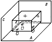
2. Если базы не заданы или задан комплект баз, лишающий деталь менее чем шести степеней свободы, то расположение системы координат, в которой задан допуск расположения или суммарный допуск формы и расположения рассматриваемого элемента относительно других элементов детали, ограничивается по оставшимся степеням свободы лишь условием соблюдения заданного допуска, а при измерении - условием получения минимального значения соответствующего отклонения.
[ ГОСТ 24642-81]Тематики
EN
DE
FR
Русско-английский словарь нормативно-технической терминологии > комплект баз
-
5 комплект баз
комплект баз
Совокупность двух или трех баз, образующих систему координат, по отношению к которой задается допуск расположения или суммарный допуск формы и расположения рассматриваемого элемента, а также определяется соответствующее отклонение.
Примечание
1. Базы, образующие комплект баз, различают в порядке убывания числа степеней свободы, лишаемых ими (например, на чертеже база А лишает деталь трех степеней свободы, база В - двух, а база С - одной степени свободы).
2. Если базы не заданы или задан комплект баз, лишающий деталь менее чем шести степеней свободы, то расположение системы координат, в которой задан допуск расположения или суммарный допуск формы и расположения рассматриваемого элемента относительно других элементов детали, ограничивается по оставшимся степеням свободы лишь условием соблюдения заданного допуска, а при измерении - условием получения минимального значения соответствующего отклонения.
[ ГОСТ 24642-81]Тематики
EN
DE
FR
Русско-немецкий словарь нормативно-технической терминологии > комплект баз
-
6 автономная система
1. single-remote application2. stand-alone application3. stand-alone systemусиленная эксплуатация, потогонная система — sweating system
4. independent system5. off-line system6. isolated systemРусско-английский большой базовый словарь > автономная система
-
7 замкнутая система
1. self-contained system2. closed loop system3. closed systemусиленная эксплуатация, потогонная система — sweating system
Русско-английский большой базовый словарь > замкнутая система
-
8 независимая система
1. stand-alone system2. independent system3. isolated systemРусско-английский большой базовый словарь > независимая система
-
9 восьмеричная система
1. octal number system2. octal systemРусско-английский большой базовый словарь > восьмеричная система
-
10 открытая система
1. open system2. open-ended systemРусско-английский большой базовый словарь > открытая система
-
11 совместимость систем
1. system compatibility2. systems compatibilityРусско-английский большой базовый словарь > совместимость систем
-
12 старение системы
1. system aging2. system deteriorationРусско-английский большой базовый словарь > старение системы
-
13 система баз
-
14 система высот
Engineering: elevations on a common datum, system of elevations, system of heights -
15 комплект баз
комплект баз
Совокупность двух или трех баз, образующих систему координат, по отношению к которой задается допуск расположения или суммарный допуск формы и расположения рассматриваемого элемента, а также определяется соответствующее отклонение.
Примечание
1. Базы, образующие комплект баз, различают в порядке убывания числа степеней свободы, лишаемых ими (например, на чертеже база А лишает деталь трех степеней свободы, база В - двух, а база С - одной степени свободы).
2. Если базы не заданы или задан комплект баз, лишающий деталь менее чем шести степеней свободы, то расположение системы координат, в которой задан допуск расположения или суммарный допуск формы и расположения рассматриваемого элемента относительно других элементов детали, ограничивается по оставшимся степеням свободы лишь условием соблюдения заданного допуска, а при измерении - условием получения минимального значения соответствующего отклонения.
[ ГОСТ 24642-81]Тематики
EN
DE
FR
Русско-французский словарь нормативно-технической терминологии > комплект баз
-
16 комплект баз
1) Mechanics: set of bases2) Automation: bearing arrangement, datum system, set of bases (совокупность трёх баз, образующих систему координат) -
17 система баз для геометрических допусков
Automation: datum system for geometrical tolerancingУниверсальный русско-английский словарь > система баз для геометрических допусков
-
18 комплект баз
bearing arrangement, (совокупность трёх баз, образующих систему координат) set of bases, datum systemРусско-английский исловарь по машиностроению и автоматизации производства > комплект баз
-
19 ось координат
1. reference lineссылка на карту; координаты по карте — map reference
опорная линия; линия отсчета; ось координат — reference line
2. axis3. datum line -
20 ощупывающая система прибоpa с независимой опорой
ощупывающая система прибоpa с независимой опорой
Ощупывающая система прибора, в которой датчик не опирается на измеряемую поверхность и перемещается независимо, сохраняя ориентацию постоянной, что достигается путем перемещения датчика по внешней базе, так что измеряемая поверхность не действует на датчик и не оказывает влияния на траекторию его перемещения относительно поверхности.
[ ГОСТ 27964-88( СТ СЭВ 6134-87, ИСО 4287/2-84)]Тематики
Обобщающие термины
EN
FR
Русско-английский словарь нормативно-технической терминологии > ощупывающая система прибоpa с независимой опорой
См. также в других словарях:
Datum (geodesy) — Geodesy Fundamentals Geodesy · … Wikipedia
Datum reference — are a concept used in carpentry, metalworking, needlework, Geometric dimensioning and tolerancing (GD T) and similar activities. In carpentry, an alternative, more common name is face side and face edge . The artisan nominates two straight edges… … Wikipedia
Datum Peak — (77°58′S 163°48′E / 77.967°S 163.8°E / 77.967; 163.8) is a peak (1,575 m) near the southwest extremity of Hobbs Ridge, rising above the south side of Gauss Glacier, 1.6 nautical miles (3.0 km) west of Williams Pea … Wikipedia
Datum (process philosophy) — Datum is a term coined by Alfred North Whitehead to show the different variants of information possessed by actual entity. In the system process philosophy, datum is obtained through the events of concrescence. Every actual entity has a variety… … Wikipedia
Datum géodésique — Système géodésique Un système géodésique est un système de référence permettant d exprimer les positions au voisinage de la Terre. Sommaire 1 Définition 1.1 Système de coordonnées cartésiennes 1.2 Système de coordonnées géodésiques (ou… … Wikipédia en Français
DATUM — the given, or what is offered in an ARGUMENT or system of thought … Concise dictionary of Religion
Geodetic system — For other uses, see Geodetic. Geodesy Fundamentals … Wikipedia
Geodätisches Datum — Geodätisches Datum: Ellipsoid mit eindeutiger Orientierung zur Erde. Ein geodätisches Datum (lat. dare = geben; Ppp datum = Gegebenes) beschreibt in der Geodäsie und Kartografie die Lage (Position und Orientierung) und den Maßstab eines zwei oder … Deutsch Wikipedia
Geographic coordinate system — Map of Earth showing lines of latitude (horizontally) and longitude (vertically), Eckert VI projection; large version (pdf, 3.12MB) … Wikipedia
World Geodetic System — The World Geodetic System defines a reference frame for the earth, for use in geodesy and navigation. The latest revision is WGS 84 dating from 1984 (last revised in 2004), which will be valid up to about 2010.Earlier schemes included WGS 72, WGS … Wikipedia
Optical landing system — The Fresnel Lens Optical Landing System of Charles de Gaulle An optical landing system (OLS) (nicknamed meatball or simply, Ball ) is used to give glidepath information to pilots in the terminal phase of landing on an aircraft carrier.[1] From… … Wikipedia